Shady cartography:
Stephen Walter Maps London
by Jeroen Nieuwland
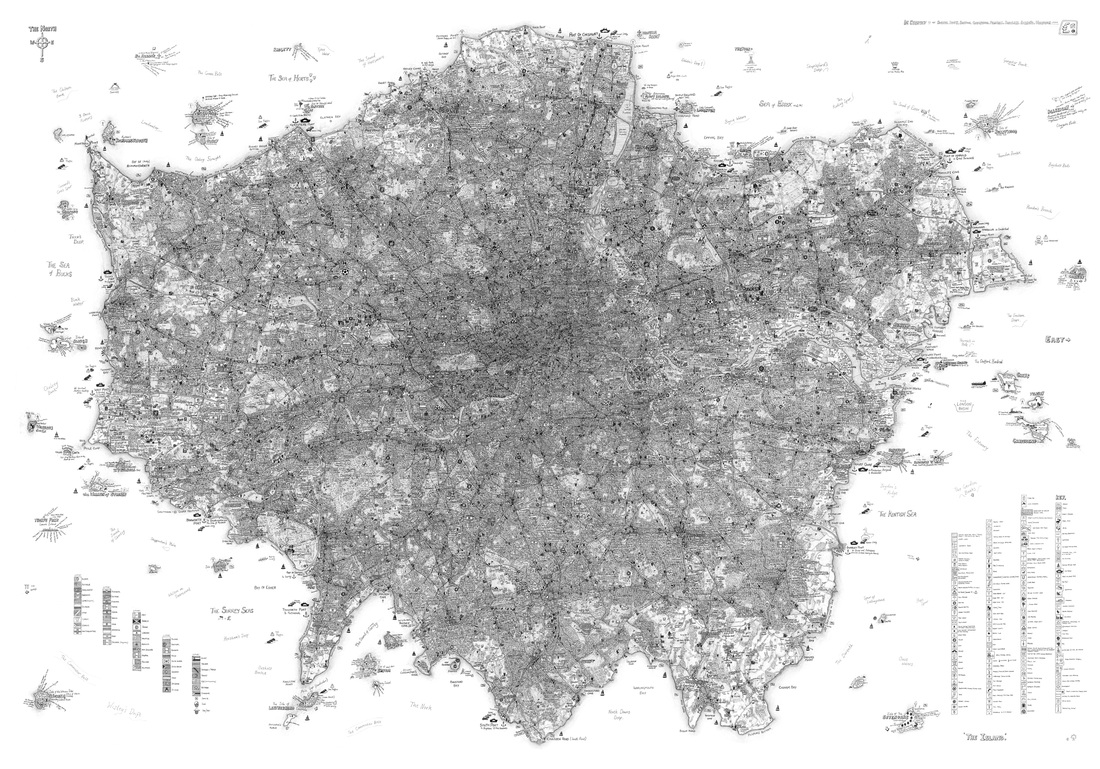
‘THE ISLAND’ LONDON In one story by Jorge Luis Borges a fictional cartographer tries to calculate how to make a 1:1 map of England. He comes to the conclusion that in order to do this, the image would have to include the map itself, leading to an infinite regression. This story has analogues such as the Droste effect and Bertrand Russell’s paradox of a set containing itself. Gregory Bateson makes a similar point about infinite regression in an illuminating passage: We say that a map is different from the territory. But what is the territory? Operationally, somebody went out with a retina or a measuring stick and made representations which were then put on paper. What is on the paper map is a representation of what was in the retinal representation of the man [sic] who made the map; and as you push the question back, what you find is an infinite regress, an infinite series of maps. The territory never gets in at all… Always, the process of representation is only maps of maps, ad infinitum.[1] Umberto Eco’s ‘On the impossibility of drawing a map of the empire on a scale of 1 to 1,’ is a satirical demonstration of the practical difficulties of such an endeavour. One central problem that would arise is that a part of the whole would represent the whole, en abyme. There would be a continual forethrow of representation, or “metonymic recursion” in which each time a part of the whole represents the whole – a “recursion of the inassimilable.”[2] The artist Stephen Walter – perhaps having read Eco’s essay – wisely decided against trying to draw a 1:1 map of England. He has, however, made an artistic cartographic rendering of London, with a similar effect of metonymic recursion as that described by the cartographer in Borges’ story. Walter has drawn London as an island, with the shore starting at its bordering boroughs (perhaps partly to avoid infinite regression of another kind; that of never finishing the map). A version of London that is, in its insularity, reminiscent of another map of London and environs, “A Londoner’s view of the North.” The latter is a grossly simplified cognitive, fictionalized map, drawn as one very rough, thick line and depicting anything beyond London as pretty much the end of the world, with Ireland marked simply as one island with a question mark, railways ending at Manchester, and icebergs, the arctic circle and dog sledges starting at the level of Scotland.[3] Although as Ljungberg points out, in concurrence with Bateson’s statement above, every mapping is already a kind of cognitive mapping, involving as it does, some kind of mental process. Similarly to this depiction of London as the end of the world, Walter’s map also isolates London and depicts nothing but London as an island, directly zooming in on one part, a fragment lifted from the whole; London as an island, instead of Britain as an island. “Britain is a collection of islands… I wanted to show London as one of those islands,” Walter writes in an artist’s statement.[4] 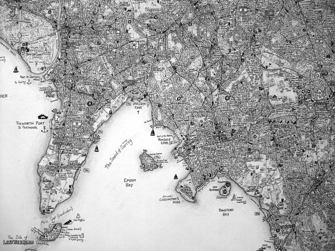
COLLAGE OF SIGNS But this feedback loop, in which a part is generated by but also mirrors the whole, recurs throughout Walter’s map of London. Because while it is a geographically accurate map of London, it is filled in with depictions of signs, facts, stories, and myths about the city. Walter, who was born in and lived most of his life in London, mixes personal memories and experience and documented fact; a fascination with the contemporary culture of signs and the myths that can be found in every corner of the city; Wikipedia entries and literary anecdotes. In other words, the city of London, which constructs a network of signs, is in turn also figuratively or literally replicated by these signs which proliferate everywhere. This resembles what in cybernetics (the study of self-producing systems) would be called an “autopoietic machine”: a network that “gives rise to components which, through their interactions and transformations, regenerate and in turn realise the network or processes that produced them.”[5] If not strictly an autopoetic machine, the map nevertheless becomes a collage of excess that can be read as an act of resistance, as what Guy Debord has dubbed “détournement, ‘the re-use of pre-existing… elements in a new ensemble,’”[6] making possible previously inexistent combinations that are not normally part of Empire and “making an appeal to a de-labourisation or anti-work as critique of industrial positivism.”[7] The question, however, whether certain signs of capitalist industry and appetite, have been fully subverted, overturned, re-arranged, in the constellation of this map, should perhaps remain a somewhat unresolved caveat. The occasional, Ford logo, Pall Mall sign, and Golden Arch scattered across the map far from dominate the landscape. On the other hand, they are all illustrative examples of mechanisms, ideologies and strategies fundamental to the capitalist system – Ford’s assembly-line production; Pall Mall’s pseudo-claim to individual freedom and expression, McDonalds’ pervasive ostensibly transparent, clownish gregariousness.[8] Derek Beaulieu has discussed this problem in the context of modernist concrete poetry. Beaulieu disqualifies Eugen Gomringer’s idea of a “reduced language” for “poems [...] as easily understood as signs in airports & traffic signs,” as running “the risk of producing poems ‘poems’ that are airport & traffic signs.” Beaulieu continuous to argue that, the form of the modernist concrete poem today is no more than an advertisement; completely co-opted by the “golden arches,” the Nike “swoosh,” & the Dell logo. By aping slogans & corporate logos as poetic forms, modernist concrete directly & unquestioningly underwrites Capitalist exchange, & “the question remains [...] whether the conflation of concrete poetry & advertising isn’t a kind of dead end for the former.”[9] Dismissing “the form of modernist concrete poetry today” as “no more than an advertisement” seems a too sweeping statement, particularly since it is not demonstrated with specific examples. In any case, Beaulieu definitely does raise the problematic question of how, if at all, to incorporate, subvert signs of capitalism in an artwork, without the artwork being subverted by uncompromising remnants of capitalism lingering in the sign. [10] In the case of Walter’s map there is perhaps a redeeming factor in the use of signs to the nth degree. On the one hand, the map displays these signs and celebrates them, in what might be argued to be what Ron Silliman has called a “fetishism of signs” under capitalism.[11] On the other hand, the markers of capitalism combined with such a proliferation of signs from across history do produce new constellations. From this point of view the map could be seen as a geo-historical detour by way of an aesthetic recombination of signs. What Louis Armand (in reference to the CollageMachine, “an interactive agent of web recombination”) calls an “aestheticisation of production” (i.e. of information),[12] here becomes an aestheticisation of signs, and of the inassimilable (the myths, stories, (unverified) facts) of the city. The two fundamental laws of détournement are the loss of importance of each détourned element… and at the same time the organisation of another meaningful ensemble that confers on each element its new scope and effect. Détournement has a peculiar power which obviously stems from the double meaning, from the enrichment of most of the terms by the coexistence within them of their old sense and their new, immediate sense… détournement is first of all a negation of the value of the previous organisation of expression.[13] In this sense the Island Map certainly constitutes a détournement, by way of creating an ensemble in which the elements gain new meaning through their unorthodox, playful, and trans-historical combinations. CHARLES OLSON’S CARTOGRAPHY This notion of Walter’s map as a détournement of present-day London, bears fruitful comparison to Charles Olson’s poetics. In The Maximus Poems Olson (1910-1970), of course, also mapped the history of one place, Gloucester (Massachusetts), using that city as a prism for American history, and arriving at universal truths through descriptions of the local. Olson’s project – more pronouncedly than Walter’s – was one of writing a republic, of discovering the polis at work in everything. However, never the republic, never the way things were ordained to be, but always with a turning away. “What the poet has seen or done regarding the nation suggests a motive for the project of writing a republic, even if that motive is aversive, a turning away.”[14] In the 2009 documentary Polis is This, he is described as a teacher who had no time for convention, would teach all day, then go for beers with his students and return to class at night. He taught a course on “the present” in which the class would read newspapers, an extension of his poetics in the classroom; anything could serve as the springboard for novelty, the détournement of tired, received, common-sense knowledge into new meaning. “No visers aloud [sic]!” concurs one corner of Walter’s map. 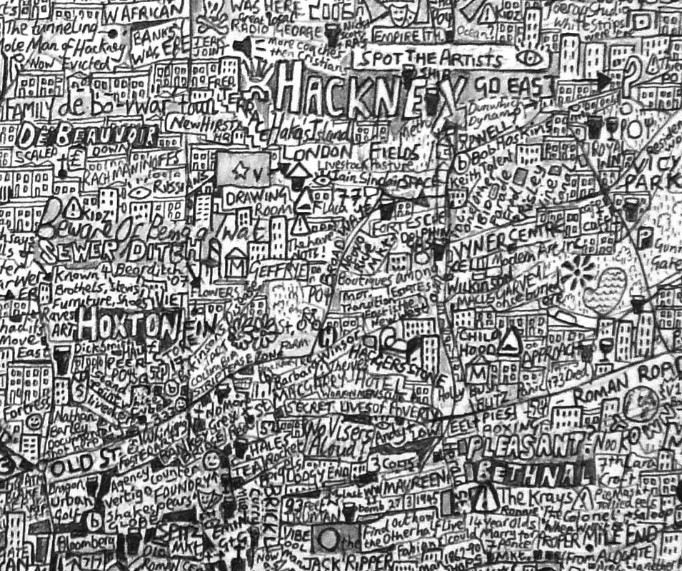
Olson’s “[p]oetry as that form of discourse which distracts the state…” becomes directly relevant to Walter’s map-making projects. Both artists dis-tract, “not simply by diverting… attention from the good, but by drawing it apart, dispersing and multiplying its loci of value; not just by constituting a space alternative to that of the state-form, but by de-gridding the concept of state-space, revealing it as lumpy, heterogeneous, desquamated; energizing it into spills and flows. Field as phasal, tendential, in formation.”[15] Thus, both Olson’s and Walter’s creation/discovering of a republic is “not lawmaking at all in the regulatory sense (gridding of the state-form), but instead wayward line-making, surveying: walking and mapping the eccentric boundaries of possibilities for social assemblage (elements gathered across time as well as space).”[16] Walter’s map accurately reproduces London’s main features – roads, waterways and population density; however, at the same time new lines emerge, signs of BBC, IKEA, and $, proliferate as virtual neighbours of Jack the Ripper, “the 1st Earl of Salisbury having honeymooned in 1589, in what is now a dodgy part of Edmonton,” and “secret lives of poverty.”[17] MAPPING THE SHADOWS OF HISTORY “The Island” tells the history of London in one of the uncountable ways that it might be told, but certainly not from official knowledge, at least not only. In this map facts from history books relinquish their hegemony to constitute – as a heterogeneous collage – an alternative story of London. In “The Island” Walter is literally “shoring the fragments against his ruins” and in doing so educates – in Walter Benjamin’s trusted poetic formulation – “the image-making within us, raising it to a stereoscopic and dimensional seeing into the depths of historical shadows.”[18] It is fitting therefore that Walter’s map, although very large (app. 1 x 1.5 m) requires the use of a magnifying glass to be read. Umberto Eco asserts that, “every 1:1 map of the empire decrees the end of empire as such and therefore is the map of a territory that is not the empire.”[19] Although meant as an argument for the impossibility of drawing such a map, we could also read it as the description of an event, arising as a rupture from within the existing map. The same could be said of Stephen Walter’s alternative rendering of London; an accurate map that is nevertheless also rearranged into a virtual constellation of facts and fiction. “The republic as resonant body whose emptiness enables its writing – not as a filling of that space, not as fulfilment, but as a concretizing of the invisible within it. If ideology is what disallows the seeing of what lies before us (ob viam = in the way), then hearing those lies as history’s echoes is what art may permit.” |
[1] Gregory Bateson, cited in Louis Armand,
|
Pamphlet. Magazine - 2014 -
